For any use of my photos, please contact me at monika.wieland (at) gmail (dot) com

Monday, October 8, 2012

Arches National Park ~ Day 2

Another beautiful day at Arches National Park....and in between hikes and taking pictures, I've had time to learn a little bit about what makes this area so colorful and unique.


The rocks are red due to the iron in the rocks oxidizing. Obviously the vast majority of rocks are red, but I've also been amazed at all the other colors mixed in. White is created by water removing the iron, or another bleaching chemical reaction occurring. Black and purple are created by iron oxide and manganese oxide interacting with water and bacteria. Green rocks occur in oxygen-poor areas, like underwater, where the iron is chemically reduced.

The amazing rock formations are created when solid blocks of sandstone get cracks in them. Water enters the cracks, making them bigger, and as the edges continue to erode away you're left with fins, or narrow, freestanding slabs of sandstone. The softer interior layers then erode first, leaving an arch.

We spent most of the morning hiking to and exploring the area near Delicate Arch.

Delicate Arch

Delicate Arch

Delicate Arch

Inside Delicate Arch

Delicate Arch
There hasn't been an abundance of wildlife to see, but there's been some neat sightings. On our drive from Salt Lake City to Moab we saw two herds of pronghorn. All over the area are skittish little chipmunks, Hopi chipmunks. They're very golden in color with no black in their stripes, and they den in rock crevices:

Hopi chipmunk (Neotamias rufus)

There are also several different types of lizards. This is the most common one I've seen which I think is a desert spiny lizard:

Female desert spiny lizard (Sceloporus magister)
 Here's one in front of a petroglyph - how many people get a chance to get this shot?

Lizard with petroglpyh

Here are so more petroglpyhs: a couple horseback riders, some big-horned sheep, and a couple dogs:
Ute petroglyphs from 200-400 years ago

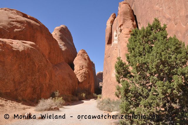
After a picnic lunch we went hiking in the Devil's Garden area. The beginning of the hike is almost like a slot canyon:

Entrance to the Devil's Garden trail

We walked as far as the Landscape Arch, the longest arch in the park at nearly 300 feet.

Landscape Arch

We also saw Pine Tree Arch and Tunnel Arch here, but the lighting just wasn't any good for photos, being partially in the shade and partially in the sun. 

But there were plenty more spectacular views....


Saturday, October 6, 2012

Arches National Park ~ Day 1

My family is off on a trip to spend a week in Utah. Today we drove from Salt Lake City to Moab, which will be our home base for the next week. We had a little bit of time to take a quick look at Arches National Park. What a beautiful place! We didn't even go far enough to get close to any of the Arches today, but all of the red rock country is absolutely beautiful. Here are a few highlights from today, just a sneak peak of what's to come:


Park Avenue


Balanced Rock


Balanced Rock

Distant view of North and South Windows

Courthouse Towers
Tomorrow will be a full day there, so there will be more to come soon!

Saturday, September 29, 2012

Marine Debris Survey

Those of you that have been following my blog for a while know that I do monthly surveys of a local beach for COASST, the Coastal Observation and Seabird Survey Team. The main focus of this citizen science project has been dead seabirds, but as part of a National Science Foundation grant they're looking to potentially expand the program to include a marine debris survey. They asked current COASSTers to photograph some debris on their local beaches to help them start the process of figuring out how to categorize debris. 


What's so interesting about surveying marine debris? You might be surprised!

Recently, a lot of debris from the Japanese tsunami has been washing up on Pacific Coasts. In addition to being interesting for beach combers, some of these debris pose greater risks than other trash in that they might introduce non-native species to our local coastal areas. A piece of a dock that washed up in Oregon had almost 2 tons of living marine organisms on it. Some tsunami debris has even been returned to their owners; a basketball that washed up in Alaska was returned to a school in Japan, where the kids were thrilled to receive it back.

Some native barnacles growing on a rusted piece of old anchor

It doesn't take a major marine catastrophe to make marine debris important, though. Even the run-of-the-mill beach trash may contain important information. Plastic lighters are notorious for their impacts on seabirds after being ingested in great numbers by birds like albatross. But did you know albatross are far more likely to ingest a red or orange lighter than a blue or black one? What if we could use this information to help protect albatrosses?


I remember reading about a waterside clean up in the Puget Sound area that quantified the different types of garbage they picked up. I believe plastic bottle caps and lids over 2" are recyclable, while smaller ones aren't. They found large quantities of small bottle caps, and only one larger one. Does this mean recyclable items are less likely to turn up on beaches than non-recyclable ones?


Debris can also tell us about weather and oceanic currents and how they influence debris. Have you ever heard about the 28,000 rubber duckies that fell off a cargo ship in the Pacific Ocean in 1992? They're still washing up on beaches 20 years later, continuing to inform scienctists about how our oceans work. Some have even found their way to Europe!


 It will be interesting to see what COASST comes up to do their marine debris survey. Some things they hope to do with such surveys include directing clean-ups to the most littered areas, further understand weather patterns that bring debris to shore, define which fisheries contribute to fishery-related debris, and look at the relationship between shore and ocean debris.

While I found some debris (not that much - San Juan beaches are usually pretty clean), I didn't find any dead seabirds, as per usual. There was still plenty of else to look at, however including live birds. The winter seabird are starting to show up in numbers. There were probably 600+ scoters - mostly surf scoters but a few white-winged, too. I also saw 10 or more common loons, horned grebes, and red-necked grebes. Another surprise just because of their numbers was a flock of over 50 northwestern crow!

The one other picture I had to stop and take was of these clouds over towards the Straits. How many cloud types do you think there are in this photo? It was an impressive sight!


Sunday, September 16, 2012

Superpod in Boundary Pass

The Southern Residents have continued to make brief visits to inland waters over the last month, and last night I got word that the whales were heading east through the Strait of Juan de Fuca again. I went to the west side early this morning, but I wasn't early enough to catch the whales - apparently they passed the Lime Kiln area between 4 and 6 AM. Here was the sunrise as seen from Bailer Hill Road:


When I heard Jim Maya of Maya's Westside Charters still had a space on his morning trip, I jumped at the chance to go out. It turned out to be a pretty epic trip with a superpod up in Boundary Pass between the San Juan Islands and the Canadian Gulf Islands. To see a slideshow of all the following whale photos or to order prints, check out this link to an album on my Zenfolio site.You can also see larger versions of all the photos there.

The first whales we saw were right off Monarch Head near Saturna Island, BC. The cliffs in this area make for a stunning backdrop when viewing whales! The first two whales we saw were L72 Racer and her son L105 Fluke. Here's Racer:


At first, the whales all seemed to be pretty spread out and doing some foraging. Before long, a few other whales came up to join Racer and Fluke. It was four whales from J-Pod - here are J2 Granny and J8 Spieden. At estimated ages of 101 and 79, they're thought to be the oldest two whales in the Southern Resident Community:


With them were J19 Shachi and J41 Eclipse:


Captain Jim, a great naturalist in addition to a great captain, is also a photographer. That means he knows how to set up the great shots when it comes to lighting, background elements, etc. It was a bit of a hazy view of Mt. Baker today, but we got several chances to photograph the whales with the mountain in the background:


Speaking of lighting, it was just perfect when we were surprised by a breach. Luckily I was ready, because there was only one - but what a breach it was!!! One of my best breach shots ever:

This one really must be seen bigger - click again on the new screen to see the enlargement


Looks like just one whale, right? Not so! The extra black under the belly of the whale on these two shots made me take a closer look. The third shot in the series revealed what I was seeing - a second whale was doing a high spyhop behind the breaching whale! You can just see its head here behind the upper pectoral fin of the breaching whale:

Click here to see a larger version - click again on the new screen to see it larger still
Whew! If that were the end of the trip I would have been content, but there was a lot more to come. Soon after this the whales seemed to group up in the bay north of Monarch Head, and large groups of whales went back and forth several times as they seemingly were trying to decide which way to go. For the first time in quite a while, they finally decided to continue on north up towards East Point and then the Fraser River, rather than heading back south and right back out to the open ocean.

As they all went north, we stayed in more or less the same spot as wave after wave of whales came by. It was so cool to see so many dorsal fins!

K22 Sekiu and younger brother K37 Rainshadow, demonstrating nicely how family members often surface in synchrony
Two year-old K44 Saturna, named after Saturna Island, which is seen here in the background

The lighting was such that you could see rainbows in some of the blows - an effect I like to call "rainblows":

K26 with a bit of a "rainblow"
Rainblows
We followed them further north up Boundary Pass, where most of J-Pod had grouped up. Baby J49 was in this group, seen here on the far left. At between 5 and 6 weeks old he/she is still very pink:


Lots of whales, everywhere you looked!


The two large males seen here are J27 Blackberry (left) and L87 Onyx, who is still traveling with J-Pod
From left to right: J34 Doublestuf, his mom J22 Oreo, and Oreo's niece J32 Rhapsody
As the whales approached East Point, there were lots of shore-based whale watchers in for a treat. Just like Lime Kiln on San Juan Island, the whales often pass very close to shore here. Check it out!


At this point it was time for us to let the whales continue north towards the Fraser River and make our way back to Snug Harbor. Along the way back we made a stop at East Point where we saw four Steller sea lions in the water:


It was a pretty darn epic morning on the water!