For any use of my photos, please contact me at monika.wieland (at) gmail (dot) com
Showing posts with label arches np. Show all posts

Tuesday, October 16, 2012

Canyonlands National Park

The stars at night near Moab were spectacular. Even when there were some clouds during the day, the skies seemed to mostly clear every night. The Milky Way Galaxy was clearly visible, as shown here in this 25 second exposure I took one night:


Early Thursday morning my dad and I went back to Arches for a sunrise, and we decided to watch from the Delicate Arch view point. It actually took quite a while from when the sun came up until it hit the arch, but it was still pleasant to sit quietly and watch the landscape change colors during the 90 minutes before and after sunrise. I even heard a canyon wren during that time! Here's the view from the upper viewpoint after the sun illuminated the arch:

Delicate Arch, as seen from the upper viewpoint

After breakfast we drove to Canyonlands National Park. We only had time to visit the Island in the Sky region on this trip, but we had time to do several short hikes there and see all the major viewpoints. You enter the park on the top of a mesa, named the Island in the Sky because it is only connected to the surrounding land by a narrow strip known as "The Neck", and on all other sides drop the canyons into the Colorado and Green River valleys. 

It's hard to imagine this land was once a flat plain; it is now divided into three different levels, each separated by about 1000 feet in elevation. We stood on the Island in the Sky, the next step down was the White Rim, and then below that the river gorges. The top level is the most moderate in climate, the middle level the driest and most desert-like, and the bottom level the most lush in terms of flora and fauna:

View from the Green River Overlook

One of the highlights of Island in the Sky is Upheaval Dome, which actually looks like a big crater with a mound (the dome) in the center. Both the rock structure and the erosion here are different than elsewhere in the Park, leading to several different theories as to its formation. Under one theory, the crater was formed by a salt dome, wherein salt buried from a former marine environment pushes its way to the surface. The second theory, which has been further bolstered by the most recent studies done in the area, is that it's actually an impact crater formed by a meteorite collision.

Upheaval Dome

We also took the short loop hike to see Mesa Arch, which was probably my favorite vista in the Park. There's a 500 foot drop off right below the arch, providing stunning panoramic views under the arch down into the surrounding canyons:

Under Mesa Arch
We got another look at the three tiers of Canyonlands from Grand View Point. I got a great book on the geology of Southern Utah at the Park visitor's center, so I'll probably do a couple of follow-up posts after reading that describing more how some of the amazing geological features we saw were formed. For now, do what I did, and just enjoy the view:

Looking down from Grand View Point

On our way out of the National Park we stopped at nearby Deadhorse Point State Park. The point here is also connected to the "mainland" only by a narrow neck, this one only 30 yards wide. This was actually our favorite canyon overlook of the day, looking down onto the winding Colorado River. We didn't get too lucky with the light at Canyonlands in terms of photography, and dark clouds continued to build while we were at Deadhorse Point. One ray of sunlight shone down onto the river, however:

Deadhorse Point
And a wildlife update! The coolest sighting at Canyonlands National Park was neither mammal nor bird, but insectoid. It was a *blue* larva, a surprising find in what's mostly a brown, orange, red, and tan environment. I've done some searching online and cannot turn up anything that matches to tell me what it might be, other than a comment on a photo on one site saying its probably not a caterpillar but the larva of some other insect. Does anyone have any ideas?


The bird sightings continued to be sparse, but I did add a couple of year birds, too! I realized I never mentioned seeing some red-necked phalaropes (213) in the San Juans in late August, so the loggerhead shrike I saw at Arches National Park was year bird #214. Then, at the end of the Little Wild Horse Canyon hike, we saw a rock wren (215) in the wash, making that the species to bring me to my year goal of 215!

Thursday, October 11, 2012

Arches National Park ~ Day 4

There's a prairie dog town making their home near the house where we are staying, and it took me a surprisingly long time to get some good photos of them considering they have dens right next to the driveway and in the backyard. But, they're pretty skittish little guys. I believe they're Gunnison's prairie dogs:


I've also seen a second type of lizard, but I can't figure out what type it is. It doesn't seem to match any of the species listed in the reptiles and amphibians checklist for the park....anyone have any ideas?


In the morning we went to Matheson Wetlands to do some birding in a rare high desert marshy habitat. Birds have been pretty few and far between since we arrived in Utah. Other than the ravens and occasional junco or house finch, there hasn't been much to report. At the wetlands, we saw a wider variety of species (15) and number of birds than on the rest of the trip combined. The highlight was a large mixed flock (well over a hundred birds) of sparrows and finches feeding on the seed pods of a bloomed-out wildflower. In the mix were house finches, American goldfinches, pine siskins, song sparrows, white-crowned sparrows, and the best find of the day, a single Lincoln's sparrow.

In the late afternoon and evening we made another excursion into Arches National Park, and our first stop was at Sand Dune Arch. We were surprised when we started on the trail to learn it wasn't the arch visible from the road; instead, we got hike through a couple of tall fins to the arch:


The arch itself was completely dwarfed by the surrounding fins, but was still a pretty cool sight:


After the Sand Dune Arch we went to the Skyline Arch, where we decided to hang out for the hour or so until sunset. That led to taking way too many pictures of the same thing, because after a few minutes of sitting it was inevitable you would get up and snap a few more photos. I'll only post two of those 80+ photos here. The arch doubled in size in 1940 when a huge boulder fell out of the left side:


I did find a few other things to photograph while waiting for the sunset, like this landscape look through a hole in a pile of huge boulders:


It was too cloudy for too much of a sunset, but what we did see was still pretty:


It was amusing to see how many cars were all leaving Arches in a long line just after sunset. We briefly separated ourselves from the pack a bit when we pulled over so I could take this dusk photo of Balanced Rock:


Tuesday, October 9, 2012

Arches National Park ~ Day 3

Monday morning started with a beautiful sunrise:


After breakfast, we decided to hike Park Avenue in Arches National Park. Plein Air Moab is happening right now, where local and national artists are spending a week painting amazing scenery outside. We saw one painter at the entrance to the Park Avenue trail:


Some more scenes from Park Avenue:


The red rocks are worth seeing in color, but I enjoy experimenting with black and white landscape photography, too. With some clouds, Monday morning was a perfect opportunity to try some shots:


A view of Courthouse Towers from the bottom of Park Avenue (the names could be a little better, I think):


Then we headed over to the section of the park we hadn't seen yet near Windows, another of the iconic park attractions along with Delicate Arch. On the approach to windows you pass the Cove of Arches:


While this area is considered desert, there aren't that many cacti. The one exception is prickly pear:


I also found one yucca plant:


Another interest growth is cryptobiotic crust. These tiny colonies are actually some combination of cyanobacteria, lichen, algae, fungi, and moss. It can take years for a crust to grow as big as in the photo below, and a single footstep can completely disrupt all this growth. Signs around the park warn hikers to stay on trails and avoid walking across this fragile, but critical, element of the environment. Crytobiotic crust stabilizes the sand, retains moisture, and fixes nitrogen for the desert ecosystem.


Along the one-mile loop we hiked near Windows, I soon had to stop looking down and start looking up to appreciate the views of the arches:

North and South Windows

South Window

Nearby was also Turret Arch:


While leaving the Windows area, we stopped at an overlook to a part of the park called the Garden of Eden:


After lunch, we did some exploring outside of the National Park. We drove Highway 128 along the Colorado River, for the red cliffs walled the canyon on either side of the river:


The scenery was breath-taking:


Our destination was Fisher Towers. They're made up of two different sandstone formations and are the remnants of a 225 million year-old flood plain deposit. While we didn't see any climbers on the rocks, we passed a few hiking out. Word is there's one really scary part near the top where you have to walk across a ledge that's 18 inches wide and 20 feet long, with sheer drop offs on either side.


Here's another look at the scenery along Highway 128. My dad said it reminded him of Monument Valley, which is also part of the Colorado Plateau:


The Colorado Plateau is a region of high desert that spans parts of Utah, Colorado, Arizona, and New Mexico. It's known for its amazing geological formations, and as a result is home to the densest concentration of national parks in the country. In addition to Arches, some of the other parks within "Red Rock Country" include Zion, Bryce Canyon, and the Grand Canyon.

Monday, October 8, 2012

Arches National Park ~ Day 2

Another beautiful day at Arches National Park....and in between hikes and taking pictures, I've had time to learn a little bit about what makes this area so colorful and unique.


The rocks are red due to the iron in the rocks oxidizing. Obviously the vast majority of rocks are red, but I've also been amazed at all the other colors mixed in. White is created by water removing the iron, or another bleaching chemical reaction occurring. Black and purple are created by iron oxide and manganese oxide interacting with water and bacteria. Green rocks occur in oxygen-poor areas, like underwater, where the iron is chemically reduced.

The amazing rock formations are created when solid blocks of sandstone get cracks in them. Water enters the cracks, making them bigger, and as the edges continue to erode away you're left with fins, or narrow, freestanding slabs of sandstone. The softer interior layers then erode first, leaving an arch.

We spent most of the morning hiking to and exploring the area near Delicate Arch.

Delicate Arch

Delicate Arch

Delicate Arch

Inside Delicate Arch

Delicate Arch
There hasn't been an abundance of wildlife to see, but there's been some neat sightings. On our drive from Salt Lake City to Moab we saw two herds of pronghorn. All over the area are skittish little chipmunks, Hopi chipmunks. They're very golden in color with no black in their stripes, and they den in rock crevices:

Hopi chipmunk (Neotamias rufus)

There are also several different types of lizards. This is the most common one I've seen which I think is a desert spiny lizard:

Female desert spiny lizard (Sceloporus magister)
 Here's one in front of a petroglyph - how many people get a chance to get this shot?

Lizard with petroglpyh

Here are so more petroglpyhs: a couple horseback riders, some big-horned sheep, and a couple dogs:
Ute petroglyphs from 200-400 years ago

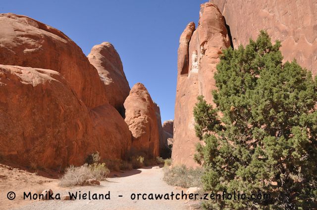
After a picnic lunch we went hiking in the Devil's Garden area. The beginning of the hike is almost like a slot canyon:

Entrance to the Devil's Garden trail

We walked as far as the Landscape Arch, the longest arch in the park at nearly 300 feet.

Landscape Arch

We also saw Pine Tree Arch and Tunnel Arch here, but the lighting just wasn't any good for photos, being partially in the shade and partially in the sun. 

But there were plenty more spectacular views....